News: Now offering a 90-day money-back guarantee!
Learn more
News: Now offering a 90-day money-back guarantee!
Learn moreNavigation apps are so deeply integrated into our daily routines that it’s easy to just rely on whatever comes pre-installed on your phone or in your car.
Navigation apps are constantly evolving with new updates being regularly added so it's important to stay on top of trends, especially if you make your living on the road.
The best navigation apps should be easy to use, and offer features like traffic and weather alerts, multiple stops, route optimization, and location sharing.
Benefits can include:
The only difficult part is choosing the right one for you since there are tons of options available. We’ve done the job for you and created a list of the 17 best navigation apps divided by the needs they suit best.
Figuring out how to get from A to B shouldn’t be difficult. Thanks to navigation apps offered by companies like Apple and Google, it’s never been easier. Let’s break them down and see which one you should use for your daily routing needs.

Price: Free
Main benefits: Integration with Apple devices, privacy, simple design
Get it: iOS
If you're already within the Apple ecosystem, using Apple Maps for your daily commutes can offer a smooth and integrated experience.
They have significantly enhanced their mapping services in recent years and it is now a worthwhile competitor to Google. Unlike Google they place a high-value on user privacy, making it a compelling choice for privacy-conscious users.
Staying true to their design philosophy, Apple Maps’ design is simple and intuitive, with fewer on-screen elements compared to other mapping apps. Where other apps provide a lot of information on their interface, Apple proves that sometimes less is more, which goes a long way in improving the user experience.
Compared to the realistic view of most GPS apps, Apple Maps offers a photographic, conceptual look, which can make its use more engaging and fun. The Look Around feature provides you with 360-degree panoramic street views, complemented by a visually appealing 3D flyover mode.
If you own an Apple device including an iPhone, Apple watch or vehicle with Apple CarPlay, Apple Maps could be the best choice for you, also thanks to its integration with Siri.
| PROS | CONS |
|---|---|
| Simple design | Only available to iOS users |
| 5 more stops than Google Maps | Less crowdsourced information |
| Integrations with other Apple devices | More information on other navigation apps |
| Electric vehicle charging station availability |
Check out our guide that shows you how to create routes with multiple stops using Apple Maps!

Price: Free
Main benefits: User-friendly, reliable, regular updates
Capterra Rating: 4.7
Google Maps, which unlike its closest competitor Apple Maps, is available on virtually every device, making it the go-to app for your navigation needs. With features like satellite imagery, 360° street view with augmented reality, and route planning for trips by foot, car, bicycle, air, and public transportation, there’s a reason why Google Maps is the most popular among free map applications.
Google Maps is not just a navigation app. It also offers real-time traffic information, music streaming and Google assistant integrations, trip progress sharing, and the AI-powered “explore tab”. Immersive view allows you to get a 3D, multi-dimensional experience view of a location, where you can preview bike lanes, sidewalks, intersections, and parking spots for your next journey. Electric vehicle drivers can also now conveniently locate charging stations using their app, which offers up-to-date details on charger availability and charging speeds.
Despite the main advantage of being 100% free, Google route planner has some limitations for teams working in industries like outside sales or delivery services. If you’re planning a trip with multiple stops, as many professionals do, Google Maps will find the best route from one point to the next, but it won’t optimize the entire route. Also you can’t add more than 10 stops to your route.
With that being said, as a GPS navigation app for small businesses without complex routing needs, Google Maps can be a good fit to meet their needs.
| PROS | CONS |
|---|---|
| User-friendly | Limited to only 10 stops |
| Free | Can't track customer information |
| Helps you find the shortest route from point A to B | Lack of customization |
| Native mobile applications for iOS and Android | No CRM integration |
| Real-time traffic and incident updates | Can't import customer contacts |
If you're a field salesperson, you can take advantage of an app that is designed specifically for field salespeople!

Price: Free
Main benefits: Real-time data, speed control, parking notifications
Also owned by Google, Waze has some similarities with Google Maps but focuses on trips by car.
Compared to Google Maps, it has more advanced real-time data on traffic conditions, road closures, etc.
Waze route planner is super reliable because it collects real-time traffic updates from users who can share live updates to alert other drivers of road conditions. Waze can even tell you where speed cops are hiding!
Waze also offers users a useful feature under the driving directions tab on their app. You can schedule a drive for a future time, with Waze reminding you when it's time to go. This can be great for planning and scheduling purposes.
Waze offers a sleek and minimal interface, with a high level of customization options. They even offer fun themes that users can choose from and even options to get voice directions by your favorite celebrities such as Morgan Freeman or Arnold Schwarzenegger. Pretty cool, right?!
Just like Google Maps, the route planner from Waze does not allow for unlimited stops to routes. You’ll need to create a new route every time, making it too time-consuming to efficiently plan your routes with multiple stops. If you’re a field salesperson, you can use Waze as the navigation system for the route planner you’ll be using for your daily tasks.
| PROS | CONS |
|---|---|
| Easy-to-use | Can only add up to 2 stops |
| Free | Cluttered layout |
| User-based data for traffic, hazards, and police detection | The app can be distracting |
Price: Starting at $58/month (Free 7-day trial)
Main benefits: Route optimization for 100+ stops, route planning, scheduling, keeping track of appointments
Capterra Rating: 4.7
For sales representatives who spend a lot of time in the field, route planning is a crucial aspect of their job. If disregarded, you will end up spending more time in your car than with your customers.
The solution to this is to automate this process with a route planning tool such as Badger Maps.
Badger Maps is the best field sales software as it allows you to automatically plan, route, and maximize your time in the field, cutting down driving time by 20%. It helps sales teams save time on their daily planning, maintain better relationships with customers, and be more productive.
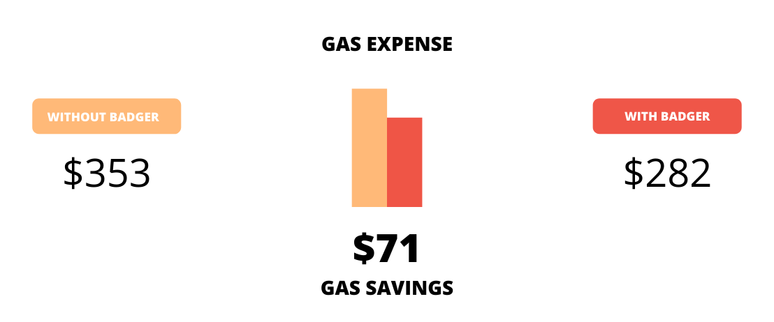
The Badger Maps route planner takes your long customer list and turns it into a drivable, optimized route. By optimizing your routes, something you can’t do with Google Maps, you will save money on gas and meet with more customers than you normally would.

With features like lead generation, territory management, check-ins, and follow-up reminders, Badger Maps not only enables efficient routing and navigation for field salespeople, but it streamlines every single aspect of a field salesperson’s job.
The colorizing and filtering tools are great for planning your days. You can visualize your top accounts with colored pins, mass update information, see who’s generating the most revenue, and much more. Filters are fully customizable so you can visualize accounts based on priority, type, next step, or any other field you find useful. Sales teams have reported that they sell 22% more and drive 20% less when using Badger Maps, in fact, the average team of 10 reps sells $936k more the year they start using the app.
"After getting Badger Maps, weekly meetings per rep jumped from 12 to 20. This led to a 22% increase in annual revenue."
Brad Moxley
Business Development Manager, Cutter & Buck
Using Badger Maps also means you can mobilize your sales CRM software, giving you instant access to important customer information as you work your territory. You can easily sync and leverage data in your CRM, all from your mobile device.
You can enable a two-way, real-time native integration with the most popular CRMs such as HubSpot, Salesforce, Zoho, Microsoft Dynamics, NetSuite, Insightly, and many more.
Additionally, field sales teams increase their CRM usage by 50% when using Badger Maps.
If you’re looking to drive more efficiently and optimize the time you spend on the road, the best GPS navigation app is Badger Maps.
On average, sales teams using Badger Maps save 8 hours a week, drive 20% less, and sell 22% more.
Discover the value of Badger Maps by trying it out yourself. Start a free trial or schedule a demo now!
| PROS | CONS |
|---|---|
| Optimize sales or delivery for multi-stop routes and get to your appointments faster | Requires Internet connection |
| See all of your customers in an interactive map | Doesn't include mobile invoicing |
| Create check-ins to keep track of completed meetings | Only available in English |
| Get instant activity reports | Doesn't automatically record deliveries |
| Sync with your CRM and update customer data from the field | Max. of 30 pin colors available |
| Great customer support |
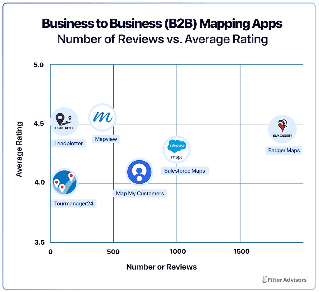
Badger is the highest ranked sales mapping and routing app, according to an industry wide analysis done by Filter Advisors, a technology consulting firm. Read more here.

Main Benefits: Lead management, gamification
Capterra Rating: 4.2
Pricing: Team - $195/mo, Pro - $245/mo,
SalesRabbit is a powerful route planning platform designed with door-to-door sales teams in mind. It streamlines lead management and customer interactions with tools like digital lead tracking, real-time team communication, e-contracts, and analytics.
What sets SalesRabbit apart is its real-time performance tracking—sales managers can monitor team activity, assess individual rep performance, and use data insights to fine-tune strategies. To keep reps motivated, SalesRabbit features built-in gamification, including leaderboards, badges, and custom contests that foster a competitive, goal-driven environment.
For businesses focused on door knocking, in-home services, or B2C canvassing, SalesRabbit delivers a specialized toolkit that boosts efficiency, conversion, and team momentum—perfect for high-energy, field-driven operations.
| PROS | CONS |
|---|---|
| Real-time team communication | Expensive |
Gamification | Steep learning curve |
User-friendly | Customization limitations |

Price: Free
Main benefits: Available offline, real-time traffic information
Like most other GPS apps in this list, HERE WeGo compares all routes to find the best one available.
It also offers offline maps for more than 100 countries around the world, which means that you can rely on it in case you lose your internet connection. But what makes it stand out on this list is that, being designed for urban areas, it provides traffic and parking data even before you begin your trip, so you know where to stop to pick up or deliver orders.
HERE WeGo works directly with automotive manufacturers. This ensures that each map update seamlessly integrates with your vehicle’s navigation system, optimizing the performance of your mapping system.
| PROS | CONS |
|---|---|
| Optimized to your specific mode of transport | Delayed GPS tracking |
| Offline maps | Routes provided aren't always the most efficient |
| Clean user interface | No option to update offline maps after download |

Price: Free
Main benefits: Updated often, available offline
If you’re a delivery driver, you might be interested in a GPS app that consumes little battery power. Because this app is fully available offline, your device will last longer compared to when using other navigation apps.
A major advantage of choosing Maps.me over other GPS apps for delivery services is that maps are updated every day by millions of individual users, making this app extremely reliable.
Disadvantages include that businesses on the map are not updated often and that when you miss a turn, it can be slow to create a new route.
| PROS | CONS |
|---|---|
| High level of detail in maps | App is prone to freeze |
| Offline maps | Free version only allows you to download 10 offline maps |

Price: Starting at $14.99 per year
Main benefits: Customizable for your vehicle type, available offline
With a traffic status bar for detailed updates and lane indicator arrows and highway signposts to change lanes in safety, this navigation app is a great choice for all driving routes.
What makes it especially good for delivery services is that on CoPilot GPS, you can customize routes based on your vehicle type (car, RV, or truck), taking road width or low clearance into account.
You also get a choice of 3 alternate routes to take, with details about trip time and distance for each. You can create maps with up to 52 stops and the app has a great search feature for any addresses, car parks, or gas stations you may need. You can even search with Yelp from within the app to find more places to go.
Although most basic navigation features are available for free, you’ll need to pay for premium features such as voice-guided offline navigation, route planning, traffic, and worldwide maps. The pricing varies based on features and vehicle type.
| PROS | CONS |
|---|---|
| 3D maps | Not user friendly |
| Offline maps | Limited to 52 stops per route |

If the button above doesn't work, please update your cookies settings here.

Price: Free
Main benefits: Instant fuel cost estimation, explore based on categories
With more than 38 million trips planned and more than 42 billion miles covered, this is one of the best navigation apps when it comes to planning a road trip.
Roadtrippers is great for exploring new places, thanks to an intuitive and engaging planning process. They have a collection of more than 300 interesting and extraordinary places that you can visit to take your trip to the next level.
Plan a trip from A to B and find places to explore within a set distance from your route. Roadtrippers also suggests places to stay along the route, with reviews and photos to help you find the perfect resting spot. You can find places to camp, sights and attractions, hotels, and cool activities to do directly from the app. You can sync with your favorite GPS app (like Google Maps) for seamless navigation.
Roadtrippers allows you to map your route with up to 3 stops free of charge. After that, there's an option to upgrade to Roadtrippers Basic, Pro, or Premium, all of which come at varying costs. Roadtrippers Premium costs $59.99/yr, coming with offline maps, live traffic alerts, and 150 stops per trip..
| PROS | CONS |
|---|---|
| Discover places you're not familiar with | Free and basic options have ads |
| Offline maps | Navigation can be unreliable |
| Free version is hard to use |

Price: Free
Main benefits: Find the best gas prices, create custom maps
MapQuest is the original mapping app having first launched way back in 1996. They set the standard for mapping tools and have stuck close to their original concept since then. With an interactive map where you can discover hotels, gas stations, grocery stores, and more, Mapquest offers real-time traffic data including traffic slowdowns, incidents, and webcams.
With this free GPS app, you can add up to 26 stops to find the best route to save you time and gas money. What makes this GPS app fun to use for road trips is that you can create custom maps to easily share with your friends and family.
Keep in mind that this app is not available offline, so you’ll need access to an internet connection to be able to use it. MapQuest is also quite outdated and lacks modern features such as lead generation, customization, or live-traffic updates.
| PROS | CONS |
|---|---|
| Simple mapping capabilities for users without complex mapping needs | Doesn't provide alternative routes when stuck in traffic |
| Ease-of-use | You have to restart a trip if you want to add a stop |

Price: Free, inRoute Pro - $4.99/mo, inRoute Pro for Families - $6.99/mo
Main benefits: Weather charts, can exports maps to other apps
Get it: iOS
With the ability to add addresses as either pins, starting point, waypoint, or destination, InRoute is one of the best choices out there for creating multiple multi-stop routes at once.
This app offers unique features such as weather alerts, elevation, and curviness.
With the free option, you can create routes with up to 8 stops. For routes with up to 150 stops, turn-by-turn navigation, and weather reports, you will have to upgrade to the paid version.
| PROS | CONS |
|---|---|
| Weather forecasts and road conditions | Limited to Apple devices |
| Sync and share routes between devices | Drag and drop pins feature can be cumbersome |

Price: Free
Main benefits: Several view options
With an option for top-down 2D view or a smart-looking 3D display and accurate live-traffic alerts, this navigation app has all it needs to be a great option for road trips and, arguably, within a better-looking interface compared to other GPS apps for road trips.
Driving instructions are accurate and timely. If you miss a turn, it’s normally quick to re-route.
Some innovative and cool features that make this app stand out are speed camera location information, photo-navigation (to navigate to places you’ve taken pictures of), a heads-up display (to limit the number of distractions while driving), a dashcam feature (that records the view out your windshield), and celebrity voices - including Homer Simpson and Snoop Dogg!
With their electric vehicle mode, users can locate nearby charging stations, check their availability, and even pay for the service directly in the app.
Although they do offer a free version, most of the key features such as real-time traffic, speed limits alerts, and voice-guided navigation will require a premium subscription.
| PROS | CONS |
|---|---|
| Innovative features | Persistent ads |
| Offline maps with 3D buildings | App is unreliable |


Price: Free region, Single Region - $ 3.99, Region Bundle - $ 8.99, World Pack - $29.99, Premium - $59.99/year
Main benefits: Offline mapping and navigation, great for unsurfaced paths
Komoot is a great GPS map option for those that practice sports like biking, hiking, and running.
Bike lovers can choose to use a road bike, touring bike, or mountain bike, and Komoot will find the most appropriate route (bigger roads for road bikes, unsurfaced sections for mountain bikes, etc.).
What makes this sports GPS app different from any other is that users can add highlights and POIs. That means that if you want to explore an unsurfaced area, you can choose some of the highlights added by other users and ask Komoot to create a route that includes them.
When it comes to pricing, Komoot offers one single region for free, which is good to try out the app and see if you like it. Then, you can either buy regions at different pricing points.
| PROS | CONS |
|---|---|
| Great compatibility with smartwatches | Too many ads |
| Easy-to-use | Satellite connection issues |

Price: Free version, AllTrails+ - $35.99/year
Main benefits: User-friendly, activity tracking, discover new hiking routes
With road, satellite, and topographic map views, Alltrails helps you find your perfect hike, bike ride, or trail run.
With 400k+ hand-curated and verified trail maps contributed by a community of sports enthusiasts, you can find the best route for you with filters like length, rating, and difficulty level. You can also look for dog or kid-friendly trails.
Although it requires an internet connection, with an AllTrail+ subscription ($35.99/year), you can download maps for offline navigation, along with other extra features.
| PROS | CONS |
|---|---|
| Offline maps | App updates have removed some favorite user features |
| Track your distance | App funcionality can be inconsistent |

Price: Free
Main benefits: Built-in compass tool, ability to record your tracks
Get it: Android
Used mostly as an off-road hiking, nautical, and trail GPS app, Polaris GPS Navigation offers an incredible amount of features that can maximize your outdoors experience in safety.
If you’re a first-time user of a GPS app for outdoor sports, Polaris might not be the best choice because of a steep learning curve and because all the features on the main screen can be overwhelming.
However, if you know how to use a compass for navigation, and you find latitude, longitude, altitude, and other information useful, or you value features such as sunset/sunrise tracking features and satellites tracker, then this GPS app for android is definitely the best choice for you.
Just keep in mind that most of these features require an internet connection.
| PROS | CONS |
|---|---|
| Highly-accurate | A lot of ads in free version |
| Functions well for off-road driving | Only available on Android |

Price: $5.99
Main benefits: Accurate location tracking, augmented reality display
With an incredible number of tracking features including a mil-spec compass, gyrocompass, real-time viewfinder, tactical GPS, speedometer, altimeter, and a sextant with rangefinder, Spyglass uses your phone’s camera and hardware sensors to calibrate your exact positional information.
And that’s not all! With Spyglass, you can measure the distance between two different objects, and find your way using the location of the moon and stars.
Just like with Polaris, these and other features can be overwhelming if you’re a beginner.
However, Spyglass is the perfect iPhone GPS app for expert outdoor sportspeople.
| PROS | CONS |
|---|---|
| Offline maps | App is unreliable |
| Augmented Reality (AR) Compass | Complicated onboarding process |

Price: Free
Main benefits: Travel options based on time, cost, and energy
With the mission of “making cities usable”, Citymapper is the best navigation app to get to any destination by public transport.
Although its main focus is on buses and trains, you can use it to plan a journey by any means of transportation, unlike other similar apps.
The most useful feature is to see the status, destination, and time until your train or bus will arrive, along with other useful information.
The only downside is that it’s only available in major cities with lots of tourists and commuters.
However, you can vote for the next city to be added to their website.
Citymapper is definitely the best choice for commuters.
| PROS | CONS |
|---|---|
| Comprehensive information about your movement/destination | Connectivity issues |
| Reliable for commuters | GPS directions not always accurate |
Using a navigation app is already the norm for most people.
But because there are so many options out there, sometimes it’s easier to stick to the one you’ve always used without looking if there’s an option that is more suitable for your needs.
However, if you're looking to branch out and try a new tool, there are countless options out there for you to choose from.
Hopefully, this list has helped you find the best navigation app for your specific use case.
The best way to be 100% sure is to download a couple from the category you need. A lot of them even offer free trials where users can get an understanding of the app before committing to a subscription.
It depends on your specific needs. For general navigation, Google Maps is the most reliable and easy to use. However, there are apps that specialize in specific categories. For example, for field sales routes or field services, Badger Maps is the best all-in-one navigation app.
The best free app for navigation is Google Maps. However if you need a navigation app for outside sales or field services, Badger Maps is an app for field teams that connects with Google Maps to give you the best possible driving experience while you are visiting customers.
You can track a salesperson’s activity with Badger Maps. Its advanced reporting feature gives you information about your reps’ activity in the field. To track their GPS location at all times, you can use a system like Hubstaff.
Google Maps is a great navigation tool since it’s easy to use, reliable, and free. However, if you need to optimize more than 10 stops on a regular basis, you should consider looking into more specialized software like Badger Maps (for sales and field services). You can find more information on Google Maps’ limitations and alternatives here.
See the potential return on investment you can get by using Badger Maps with your field sales team.
Badger Maps is a routing & mapping app that automates data collection and uplevels field team performance. From planning your day to managing your territories, Badger optimizes every aspect of the field sales process.
Looking for our logo?
Grab a Zip packed with our logo in PNG and EPS formats.