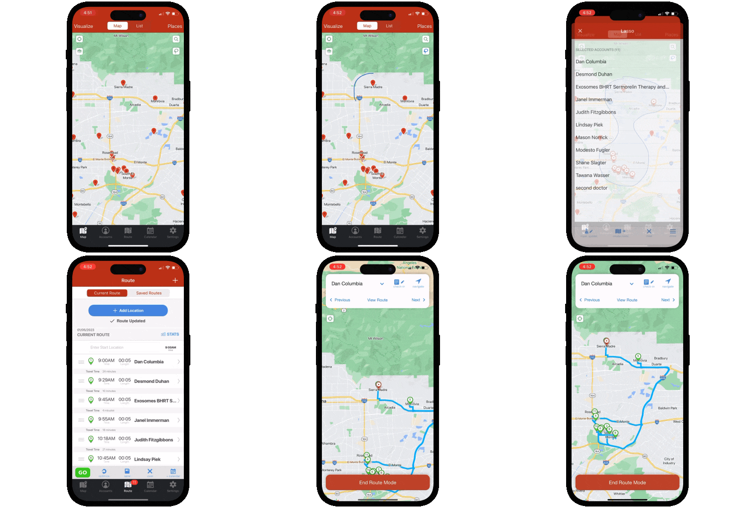
Review & Compare: Geopointe vs Badger Maps
Which Field Sales Tool Is Right For You?
Badger Maps and Geopointe have traditionally served different people. Simply compare their subheadlines on each of their home pages: Geopointe wants users to “Drive field productivity and market coverage by turning location data into actionable intelligence - not just visualization.” while Badger Maps “combines a route planner, sales mapping, CRM integration, and AI automation into one mobile-first platform built for how reps actually work. Reps sell more, managers get the visibility they need, and the whole organization scales without the growing pains.”
Geopointe was built for office-based teams doing geospatial analysis inside Salesforce - operations managers visualizing territories, marketing analysts identifying campaign focus areas, business intelligence teams modeling where to open a new location.
Badger Maps was built for the rep in the car and their managers - visiting business accounts, optimizing routes, capturing field activity, and generating leads while already in the territory.
Over time, both platforms have expanded toward each other's space. Geopointe now claims field sales capabilities. Badger Maps now covers territory alignment, geospatial analytics, and operations-level mapping through Badger Align and Badger Insights. But focus makes you strong. And when the end users are field sales reps (and their managers) who need their tool to work reliably on a phone between appointments, that difference in origin shows up clearly.
This guide breaks down the real differences so you can make the right call for your team. Let's dive in!
Badger Maps vs. Geopointe: Which Field Sales Tool Is Right for You?
What Is Geopointe?
Geopointe is a geospatial analysis and mapping platform built natively on Salesforce, sold through the Salesforce AppExchange and developed by AscentCloud (which acquired the original Geopointe company in 2019). It requires an active Salesforce license to function and layers geographic intelligence on top of Salesforce data.
To illustrate: a sales operations manager at a national retailer can use Geopointe to analyze geographic concentrations of customers across Salesforce data, design territory assignments across a team, identify coverage gaps, and build routes for each rep's week.
Why users like it: Reviewers praise the native Salesforce integration for keeping all geographic data within the system of record, the depth of geospatial analysis capabilities for operations and marketing teams, and the ability to build complex map-based views of Salesforce data. For office-based teams doing Salesforce-native geospatial work, reviewers describe it as a capable platform.
Why users dislike it: Three patterns show up consistently across reviews. First, mobile performance - Geopointe's end users have historically been office-based analysts, and the mobile experience reflects that origin: field reps report app crashes and freezes, and that it doesn't hold up in the field the way that they need. Second (and related to the aforementioned issue), a lot of users talk about stability and performance issues at scale - slow loading times, data propagation failures, and freezing when working with large datasets. Third, business practices around contracts - multiple reviewers describe auto-renewal notices going to spam, zero flexibility when cancellation is requested, and being charged for a full year despite prompt and good-faith attempts to cancel. As one reviewer put it plainly: "The software is average. The business practices are not."
What Is Badger Maps?
Badger Maps has been the #1 field sales app for outside sales reps for over a decade. It combines route optimization, CRM integration, lead generation, territory visualization, AI automation, and reporting in a single mobile platform - so reps can plan smarter routes, see more customers, and spend less time on admin.
To illustrate: a pharmaceutical rep can use Badger Maps to map every hospital and clinic in their territory, filter by last visit date and priority, build an optimized multi-stop route around their highest-value accounts, discover new leads nearby with the Lead Generation feature, and sync every check-in automatically back to Salesforce - all from their phone before leaving the parking lot.
Teams using Badger Maps see an average 22% increase in sales, 20% less time spent driving, and 50% less time on admin tasks.
Why users like it: On the App Store and Google Play (where it scores a 4.5 and 4.0, respectively), users consistently praise the route optimization for saving meaningful time in the field, the reliability of the CRM sync for eliminating double data entry, and the responsiveness of the customer support team.
Why users dislike it: Some users note that they prefer the mobile app to the desktop experience. Pricing can feel steep for individual reps paying out of pocket rather than through a company plan - though many report the time savings make it pay for itself quickly.

Who Each Tool Is Built For
The honest answer is that these two tools were built for different people - and understanding that distinction is more useful than comparing feature lists.
Geopointe was built for office-based Salesforce users doing geospatial analysis: operations managers visualizing territories, marketing teams analyzing where to focus campaigns or place new locations, business intelligence teams building geographic views of Salesforce data. If your end user sits behind a desk and works inside Salesforce all day, Geopointe's depth of geospatial analysis is strong for that workflow.
Badger Maps was built for reps in the field (and their managers). If the user needs to be visiting business accounts, optimizing driving routes, capturing visit notes, generating new leads while already in the territory, and keeping CRM data accurate without manual entry at the end of the day. The mobile experience is the product - not an afterthought.
Both platforms have since expanded toward each other's space. Geopointe claims field sales capabilities. Badger Maps covers territory alignment and geospatial analytics through Badger Align and Badger Insights. But focus builds strength. A platform built for desk-based analysts will reflect that in its mobile experience - and a platform built for field reps will reflect that in its routing and in-field productivity tools.
Geopointe is a strong fit if you:
- Are doing Salesforce-native geospatial analysis from a desktop - marketing analysis, coverage modeling, or business intelligence work that lives entirely within the Salesforce environment
- Have a Salesforce admin team available to configure and maintain an AppExchange product that's on the more complex side
- Don't need a purpose-built mobile field experience - your end users are primarily office-based analysts, not reps driving a territory most days
Badger Maps is built for you if you:
- Are a B2B outside sales manager or rep visiting business accounts every day who needs a mobile-first tool that works reliably in the field (scoring 4.5 on the App Store!)
- Need your tool to work on your phone between appointments in parking lots and low-signal areas, not a desktop platform accessed through the Salesforce app
- Already use a CRM and need it to stay accurate - Badger integrates natively with Salesforce, HubSpot, Microsoft Dynamics, Zoho, Netsuite, Pipedrive, and others - you're not locked into a single ecosystem
- Need to find new leads while already in the field - Badger's Lead Generation feature surfaces nearby business prospects in real time so reps can add a new account to today's route without switching tools
- Want to be productive on day one - free 14-day trial, no Salesforce admin required, no AppExchange configuration before reps can use it
Badger Maps, the Highest Ranked App in the B2B Sales Mapping Apps Category

Badger is the highest ranked sales mapping and routing app, according to an industry wide analysis done by Filter Advisors, a technology consulting firm. Read more here.
Key Differences - Features & Reviews
1. Mobile Experience: Built for the Field vs. Built for the Desk
This is the most predictable difference between the two tools - and the most important one for field sales teams to understand.
Geopointe was built for office-based Salesforce users. Its core features - geospatial analysis and coverage modeling - are desktop-first by design. The mobile experience exists, but it runs through the Salesforce app rather than as a standalone purpose-built field tool. For a rep who needs to pull up their route in a parking lot, check in after a visit, and navigate to the next account without losing their place, that distinction matters. Reviewers flag it directly: "the mobile and desktop experiences are similar but not equal." Another: "Platform is buggy and freezes a lot. Does not appear to be made well for enterprise companies. Currently cannot even get a map to load without it crashing."
The mobile limitation is predictable given Geopointe's origin - when your primary end user is an analyst at a desk, mobile is a secondary consideration. But when field sales reps are asked to use a desktop-first tool from their phone between appointments, the friction shows up immediately.
Badger Maps was built from the ground up for the rep in the car. The scores in the app stores reflect a product designed for exactly that use case - stable while navigating between accounts, with route context that persists, data that sync automatically to the CRM, and a lead generation feature that works in real time while you're already in the area. And though the mobile experience is central, the desktop experience also exists and works very well.
2. Performance and Stability at Scale
Both platforms work with large Salesforce datasets - but the reviews suggest Geopointe struggles when those datasets get large or complex:
"Platform is buggy and freezes a lot. If you click the wrong button it loads thousands of data points and freeze." Another: "It was slow and did not return all the results. It was also disconnected twice, resulting in no data propagating." A third: "Slow Loading Times - especially during the initial load. This has been particularly noticeable when working with large datasets." And from a reviewer focused on the core use case: "I've found using shapes based on rather weighty data can take some time."
For a $75+/user/month platform marketed to enterprise Salesforce organizations - which by definition have large datasets - performance degradation under load is a meaningful limitation. The "write a trigger to do that" complaint from one reviewer - describing how a core territory assignment feature required custom Salesforce development to function as expected - is particularly telling. When a paying customer has to build custom code to make a feature work, the product hasn't delivered on its promise.
Badger Maps' performance story is different by design - the platform is optimized for field rep workflows rather than large-dataset geospatial analysis, which means the operations it performs most frequently are the ones most reliably optimized.
3. Customer Service and Contract Practices
This is where Geopointe's reviews go from "product limitations" to "trust concerns."
Some reviewers describe having nearly identical experiences: auto-renewal notices going to spam, prompt cancellation requests being denied, and being charged for a full year of service they didn't intend to use. "Auto-renew emails go straight to spam. Zero flexibility." And from a long-term customer: "Awful Customer Service. We used this service for years and when we were ready to move on, found deactivation very challenging. We were charged for a whole year of service a few days before we finally managed to deactivate, and they will not provide a prorated refund. This is a frustrating way to end an otherwise positive relationship, and poor treatment of a longtime customer."
One reviewer's summary captures it best: "The software is average. The business practices are not." And a warning specifically for smaller organizations: "For small and mid-sized businesses, this is a serious red flag. Once you sign, you're locked in, and getting out is intentionally difficult even when you act promptly and in good faith."
Badger Maps offers a 14-day free trial with no credit card required - you validate the tool before committing. And a 90-day money-back guarantee means if it doesn't deliver results after purchase, you get your money back. No fine print, no auto-renewal traps.
4. Pricing and Total Cost
Geopointe starts at $75/user/month - the same entry point as Salesforce Maps - plus your existing Salesforce license cost, plus additional license tiers for full analytics capabilities. Reviewers flag the hidden cost structure directly: "A bit more clarity on what you can and cannot do with a license. There are some functions that you get a scattering of capabilities on which you can find that you'll need to pay more for to really unlock." For a team expecting the $75 sticker price to cover the full feature set, discovering that core capabilities require additional licensing is a significant surprise.
Badger Maps starts at $58/user/month for business plans and $95/user/month for enterprise plans, with a 14-day free trial, no credit card required, and a 90-day money-back guarantee.
| How they compare | Badger Maps | Geopointe |
|---|---|---|
| Built for reps in the field | ✓ Yes | △ Desk-first design |
| Mobile app reliability | ✓ 4.5 / 4.0 | △ Utilizes SF app |
| Works without Salesforce license | ✓ Yes | ✗ No |
| Route optimization (with live traffic) | ✓ Full | △ Partial |
| Lead generation | ✓ Full | ✗ Not available |
| Phone, chat & email support | ✓ Full - all plans | △ Email only |
| Free trial available | ✓ Yes | ✓ Yes |
| 90-day money-back guarantee | ✓ Yes | ✗ No |
✓ Full △ Partial / limited ✗ Not available
Where Badger Maps Wins
For B2B outside sales reps managing a geographic territory of business accounts, Badger Maps is the purpose-built choice. The full field sales workflow lives in one place - visualize accounts on a map, build and optimize your route, check in after every meeting, generate leads nearby, and sync everything back to your CRM - reliably, from your phone, every day. It's a platform that was built for field reps first, expanded to cover territory intelligence and geospatial analytics, and Badger has never lost sight of the original use case: helping reps in the field sell more.
Where Geopointe Might Be a Better Fit
Geopointe is worth true consideration if your primary use case is Salesforce-native geospatial analysis from a desktop. For operations managers and marketing analysts who work inside Salesforce all day and need deep geospatial analytical capabilities without leaving that environment, Geopointe's feature depth for that specific workflow is genuine.

“We downloaded the app and we were up and running with Badger the next day! Implementation was seamless and cost-effective”
Steve Crooks
Director of Business Development
Switching to Badger Maps Is Straightforward
If you're currently using Geopointe and considering a switch, the transition is simpler than most teams expect.
- Free trial: no credit card required, connect your CRM and build your first route on day one
- Data import: upload your existing account list via spreadsheet or sync directly from your CRM
- Onboarding support: Badger's customer success team helps new teams get up and running quickly, and is reachable by phone when you need them
- No long-term commitment: month-to-month plans available so you can validate the tool before committing
- 90-day money-back guarantee: if Badger isn't delivering results for your team within 90 days, you get your money back.
Teams are fully operational within a day or two of signing up.
The Bottom Line
The most honest thing to say about this comparison: Geopointe and Badger Maps were built for different people. For office-based Salesforce users doing geospatial analysis, Geopointe's depth is its genuine strength. For field sales reps who need a tool that works reliably between appointments, the desktop-first heritage shows up in the mobile experience, the performance under field conditions, and the reviews from reps who've tried to use it that way.
If you need a platform built for the rep in the field - reliable mobile performance, proven Salesforce integration, in-field lead generation, and a team you can actually reach when something goes wrong - Badger Maps is built for exactly that.
Ready to see it in action? Start your free trial and build your first optimized route in minutes.
THE BEST APP FOR FIELD SALES PEOPLE
Learn how you can maximize your sales routes & sell more with Badger Maps.
What's the main difference between Geopointe and Badger Maps?
Geopointe was built for office-based Salesforce users doing geospatial analysis. Badger Maps was built for the rep in the field - optimizing routes, capturing visit activity, generating leads, and keeping CRM data accurate from a mobile app that works reliably between appointments. Both have expanded toward each other's space over time, but focus builds strength. For field sales use cases, Badger Maps is the purpose-built choice.
Does Geopointe work without Salesforce?
No - Geopointe is a Salesforce AppExchange product and requires an active Salesforce license to function. It exists entirely within the Salesforce environment. Badger Maps integrates natively with Salesforce but doesn't require it - and works equally well with HubSpot, Microsoft Dynamics, Zoho, Netsuite, Pipedrive, and others.
Does Badger Maps integrate with Salesforce?
Yes - Badger Maps integrates natively with Salesforce with two-way, real-time sync. Check-ins and notes logged in the field update Salesforce automatically, and Salesforce changes appear in Badger without manual imports - on all plans, with no additional license required.
Is Badger Maps or Geopointe better for field sales reps?
Badger Maps is significantly better suited for field sales reps. It was purpose-built for reps in the car - route optimization, mobile check-ins, in-field lead generation, and CRM sync that works reliably from a phone between appointments. Geopointe was built for office-based Salesforce users doing geospatial analysis, and the mobile experience reflects that origin.
What does Badger Maps cost compared to Geopointe?
Geopointe starts at $75/user/month on top of your existing Salesforce license, with additional license tiers required to unlock full analytics capabilities. Badger Maps starts at $58/user/month for business plans and $95/user/month for enterprise plans. A 14-day free trial and 90-day money-back guarantee are also included.
Can I try Badger Maps before committing?
Yes - Badger Maps offers a 14-day free trial with no credit card required. You can connect your CRM, import your accounts, and run optimized routes before making any purchasing decision. A 90-day money-back guarantee is also available after purchase - no auto-renewal traps, no fine print.
The names and logos for Badger Maps are trademarks of Badger Maps, Inc. All other trademarks, brand names, or product names belong to their respective holders. The purpose of this comparison is to provide customers with truthful information about competitors with no affiliation or partnership in place. This comparison is based on information gathered from the company's website and other 3rd party websites on the date written, and thus changes may have occurred.


